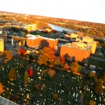
The camera is suspended from the line, which is attached to the kite, creating a bit of a shock absorber. A battery powered servo rotates the camera rig every 30 seconds and snaps a picture. Winds can blow the camera around, so we use a fast shutter of at least 1/400 second. It takes about 12 mph of wind to lift the rig. On this day, we had 15-20 mph and the kite shot up like an elevator with almost no coaxing. The view is of the Congressional Cemetery on Capitol Hill. It is a 35-acre burial ground with about 55,000 “residents.” The river is the Anacostia, a tributary of the mighty Potomac. Big thanks to kite wrangler Rasheed Willis for his exceptional work on this project.
Looking east at the end of day you can see the upper bend of the Anacostia. That building is DC Jail.
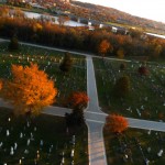
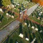
This shows the road that goes south east toward the Anacostia River. You can just make out the 11th St. Bridge.
The camera rotated toward the setting sun and these beautiful flares were a lovely accident.
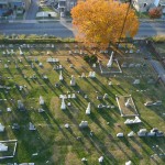
Some of the orange trees in the foreground are Cherry trees which really colored up this year, perhaps becuase of all the rains.
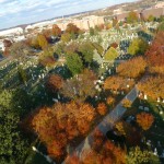
This shows the hills of Anacostia across the river of the same name.
If you follow the line down to the ground…you will see the kite operator frantically trying to bring the rig down to the ground. In 20mph winds…that thing wanted to stay aloft!
This totem pole was set up as a native american tribute to 9/11. Camera was only about 80 feet off the ground in this shot.
Whoa…gotta catch the rig before it smashes into one of those stones!
2 thoughts on “Kite Aerial Photography”
Nice shots Stew! After stretching the grid of sites and roads over the Google Maps satellite imagery and mapping range/site to latitude/longitude in our work on the HCC’s website, it’s really neat to see the place in full color (non-satellite) imagery from a similar vantage point.
You are so right, sir! I can still remember trying to figure out why the mapping fell to pieces on the slopes. Rise and run, eh?! For those who have never been….the website is Congressional Cemetery.